
Walking and Hiking in the Galtees

Boolakennedy sits at the foot of the Galtee Mountains, between the Galtees to the north and the Knockmealdowns to the south. Step outside the door and the mountains fill the view. Drive a little further and you have four of Munster's best walking areas to choose from, without packing up and moving on each night.
It makes the cottages a natural base for a hiking break. Make an early start with a packed lunch from your own kitchen, spend the day on the hills, and come back to a wood-burning stove and a proper dinner at your own table.
Why walkers stay at Boolakennedy
- The Galtees on your doorstep: Galtymore, the highest peak in Tipperary, is a short drive from the cottages.
- Four ranges, one base: the Galtees, the Knockmealdowns, the Glen of Aherlow and the Comeraghs are all within an easy day trip.
- Self catering suits walkers: early breakfasts, packed lunches and late dinners on your own schedule.
- Warm up after the hills: both Mary-Kate's Farmhouse and John's Dairy have wood-burning stoves.
- Room for walking groups: Mary-Kate's sleeps 6 and John's Dairy sleeps 4. Book both, and add Lester's Room, for groups of up to 12.
- Easy to reach: the M8 is just five minutes away, so you're on the hills soon after you arrive.
The Galtee Mountains
The Galtees are often described as Ireland's highest inland mountain range. The ridge runs east to west for around 30 km, with steep north-facing cliffs and dark corrie lakes, including Lough Curra, Lough Diheen and Lough Muskry, tucked beneath the summits. At 918 m, Galtymore is the highest point in both Tipperary and Limerick.
Galtymore via the Black Road
The most popular way up Galtymore starts from a small car park at the end of the Black Road, off the R639 near Skeheenarinky. The route follows an old mountain track before climbing to the col between Galtybeg and Galtymore, then along the cliff edge above Lough Diheen to the summit cairn, trig point and white Celtic cross.
- Distance: about 10 km return
- Time: 3 to 4 hours
- Grade: moderate to strenuous, returning the same way
- Tip: the car park holds only a handful of cars, so arrive early. Add Galtybeg (799 m) on the way down if you have the legs for it.
Circuit of Glencushnabinnia
For experienced hillwalkers, this 12 km loop from the forest car park near Clydagh Bridge takes in Cush, Galtybeg, Galtymore and Slievecushnabinnia. Allow 5 to 6 hours. It's widely regarded as the finest round in the range.
The Galtee Crossing
The big one: a full east-to-west traverse of the range, about 31 km and 10 hours or more on the hill. It's a serious undertaking that needs good fitness, navigation skills and transport arranged at both ends.
The Glen of Aherlow
On the north side of the Galtees, the Glen of Aherlow has a network of waymarked looped walks through woodland and along the valley sides, with views across to the mountains. They're ideal for an easier day, for mixed groups, or when cloud is down on the tops. Most start from the Christ the King trailhead or from Lisvarinane village.
| Walk | Distance | Time | Grade |
|---|---|---|---|
| Woodland Loop | 2 km | 30 min to 1 hour | Easy |
| Bianconi Loop | 4 km | 1.5 hours | Easy |
| Carroll's Loop | 5 km | 1.5 hours | Easy |
| Padraig's Loop | 7 km | 2 to 2.5 hours | Easy |
| Rock an Thorabh Loop | 6 km | 2.5 hours | Moderate |
| Ballinacourty Loop | 10 km | 2 to 3 hours | Moderate |
| Dolmen Loop | 10 km | 3 to 3.5 hours | Moderate |
The Knockmealdown Mountains
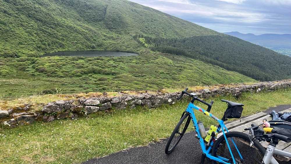
South of the cottages, the Knockmealdowns straddle the Tipperary–Waterford border. The famous Vee Gap road winds through them past Bay Lough, a corrie lake tucked below steep mountain slopes.
The easiest way up Knockmealdown (792 m, the highest point in County Waterford) starts at the layby overlooking Bay Lough on the Vee road. Climb Sugarloaf Hill first, then follow the ridge to the summit, with views back across the valley to the Galtees.
The Comeragh Mountains

About an hour away, the Comeraghs are worth the trip for one walk in particular: the Coumshingaun Lough loop. The 6 km route from the Kilclooney Wood car park climbs steeply around the rim of one of Ireland's most dramatic corries, with sheer cliffs dropping to the lake below. Allow 3 to 4 hours. It's tough and exposed, so go in good weather and walk it clockwise.
For something gentler, walk from the car park to the lake shore and back, or visit nearby Mahon Falls.
Further afield
- Devil's Bit: a distinctive gap-toothed hill in north Tipperary with panoramic views.
- Keeper Hill: the highest mountain in the Slieve Felim range, great for hiking and nature lovers.
- Lough Derg: lakeside walks around the villages of Terryglass and Dromineer.
Before you head out
Irish mountain weather changes fast, and the Galtees in particular can be covered in cloud when the valleys are clear.
- Carry a map and compass, or GPS, and know how to use them. Paths can be hard to follow in mist.
- Wear proper walking boots and bring waterproofs and warm layers, even in summer. The ground is often boggy.
- Keep well back from cliff edges, especially above the corrie lakes.
- The hills are working farmland. Close gates behind you, keep to the paths, and keep dogs on a lead around sheep and cattle.
- Tell someone your route and when you expect to be back.
- In an emergency, call 112 or 999 and ask for Mountain Rescue.
Want company on the hills? The Galtee Walking Club organises regular local walks, though some may be for members only. For more waymarked routes, the Glen of Aherlow Fáilte Society is a great source of local walking information.
Plan your walking break
Whether you're ticking off Galtymore, walking the Glen of Aherlow loops or tackling Coumshingaun, Boolakennedy puts it all within easy reach, with a warm, comfortable cottage to come back to.
View our cottages or check availability. Book direct for our best rate.
View Local Activities
Book your stay with us in Tipperary
For pricing and availability please contact us by phone or use our online enquiry form.
Book Now!